

Indian Geography/ Physiography
Indian Geography/ Physiography
Section titled “Indian Geography/ Physiography”2020-04-29 00:35:15
- Indian Geography/ Physiography
Location
Section titled “Location”- Subcontinent has Hindukush and Suleiman Ranges towards the North West.
- Sri Lanka is separated from India by the ==Gulf of Mannar and Palk Strait==.
Structure and Physiography : Division into 3 Geologic Regions.
Section titled “Structure and Physiography : Division into 3 Geologic Regions.”Peninsular Block :
Section titled “Peninsular Block :”- Delhi ridge in NW, Rajmahal hills in East, Gir in west and Cardamon in South is the outer extent
- ==Karbi Anglong , Meghalaya Plateau== and Rajasthan are the extensions of the Peninsular block
- north eastern India is separated from Chotatnagpur plateau by Malda Fault.
- formed of gneisses and granites.
- Rift valleys found in areas around Narmada, Tapi, Mahanadi, Satpura.
- Mountains are residual, River valleys shallow.
Himalayas :
Section titled “Himalayas :”- Young, weak and flexible in geologic structure
- techtonic in origin
- features like Gorges, V shaped valleys, rapids, waterfalls are common
Indo-Ganga-Brahmaputra Plain
Section titled “Indo-Ganga-Brahmaputra Plain”- gradually filled by sediments
Physiography or Physiographic Division
Section titled “Physiography or Physiographic Division”- Physiograhy : outcome of structure, process, and stage of development
Northern and North Eastern Mountains :
Section titled “Northern and North Eastern Mountains :”- consists of Himalayas and NE mountains.
- important ranges are Great Himalayan consisting of Trans. Himalayas and Great Himalayas, Middle Himalayas and Shivaliks.
Sub Divisons of H
Section titled “Sub Divisons of H”Kashmir/ North Western Him
Section titled “Kashmir/ North Western Him”- comprises of Karakoram, Ladakh, Zaskar, Pir Panjal.
- Baltoro, Siachen imp glaciers .
- famous Karewa formations of Kashmir for cultivation of Saffron/Zafran. Thick deposits of glacial clay etc embedded with moraines,
- Jhelum in its youth forms meander here.
- Southernmost part has dun formation ex ==Jammu and Pathankot== dun.
Himachal and Uttaranchal Him
Section titled “Himachal and Uttaranchal Him”- b/w ==Ravi and Kali== rivers
- Lesser Him locally known as Dhaoladhar in HP and Nagtibha in Ukhand.
- distinguishing features are ==Shiwalik and Dun== formations ex Chandigarh-Kalka dun, Nalagarh dun.
- Bhotia tribes migrate to Bugyals/summer grasslands during winter.
Darjeeling and Sikkim Him
Section titled “Darjeeling and Sikkim Him”- have duar formations no Shiwalik; fast flowing rivers viz Tista.
- Lepcha tribes inhabit high reaches
- thick soil cover, high organic content, distributed rainfall, mild winters make it apt for Tea plantation.
Arunachal Him
Section titled “Arunachal Him”- Extend upto Diphu pass in the East
- imp peaks are Kangtu, Namcha Barwa.
- fast flowing rivers form deep gorges.
Eastern Hills and Mountains.
Section titled “Eastern Hills and Mountains.”- low hills, tribes practice Jhum cultivation.
- Barak imp river tributary of Meghna which itself is a tributary of Chindwin.
- Mizoram known as ==Molassis basin== due to soft unconsolidated deposits.
Nothern Plain
Section titled “Nothern Plain”- dept of alluvium is 1000-2000 mts
Bhabhar
- narrow belt b/w 8-10 km parallel to Shiwalik
- rivers deposity heavier loads ex boulders, blocks etc and disappear in this zone
Terai
- South of the Bhabhar; 10-20km in width
- streams, rivers re-emerge here making it marshy and swampy
- rich in natural vegetation and wild life ![[Indian-Geography-image1-00091255.jpg|500x300]]
Alluvial plains
- Khadar : new alluvium that is deposited by floods annually enriches the soil by depositing silt.
- They are found in flood plains and deltas.
- It is sandy and light in colour and contains Kankars or calcareous concretions.
- They become loamy and clayey in lower and middle Ganga plain and Brahmaputra valley.
- Bhangar : Old alluvial deposit that is deposited away from the flood plains.
- It is found on higher side of the river valleys ie 25 mt above flood level.
- features viz sand bars, meanders, ox-bow lakes, braided channels.
Peninsular Plateau
Section titled “Peninsular Plateau”![[#Peninsular Block]]
- made up of series of patlant plateaus.
- general elevation/slopes from ==West to East==. ?
- Imp physiographic features like Tors, Block Mountains, Rift Valleys, Spurs, Dykes etc are present.
- Ravines found at Chambal, Bhind, Morena.
- Divided into 3 broad groups
- Deccan Plateau :
- Bordered by Western Ghats in West and South, Eastern Ghats, ==Satpura, Maikal and Mahadeo== hills in North
- WG are locally known as Sahyadri in Maha, Nilgiri in Ktaka and TN, Annamalai and Cardamom hills in Kerala.
- their height inc from North to West.
- most peninsular rivers originate here.
- Central Highlands :
- Bounded by Aravalli in west, Satpura in south.
- 600-900 mts above sea level.
- ==metamorphic rocks== present.
- Eastern extent is formed by Rajmahal hills.
- North Eastern Plateau :
- Extension of main Peninsular Plateau called Meghalaya and Karbi Anglong Plateau.
- Meghalaya plateau divided into Garo, Khasi, Jaintia Hills
- Receives max rainfall from SW monsoon
- Deccan Plateau :
Indian Desert
Section titled “Indian Desert”- longitudnal dunes, barchans, mushroom rocks, shifting dunes, Oasis are some features present.
- Northern part slopes towards Sindh, Southern towards Rann of Kachchh.
- Rivers are ephemeral, lakes and playas present have brackish water.
Coastal Plain
Section titled “Coastal Plain”- Western Coastal :
- submerged -> natural conditions for dev of port and harbours
- divided into Kacchs and Kathiawar in Gujarat, Konkan in Maha, Goan and Malabar in Kerala.
- Rivers flowing through this do not form any delta.
- Kayals are distinguishing features in Malabar coast.
- Eastern Coast
- ==Broader and emergent== coast, well developed deltas
- but less ports due to continental shelf extending 500km into the sea.
Islands
Section titled “Islands”- Andaman and Nicobar islands are situated b/w 6-14 °N and 92-94°E.
- Ritchie’s archipelago and Labrynth are 2 principle islets.
- Separated by 10° channel.
- Coral deposits, convectional rainfall and equatorial vegetation.
- Lakshadweep and Minicoy are between 8-12°N and 71-74 °E longitude.
- Separated by 11° Channel.
- has storm beaches made of unconsolidated pebbles, shingels, boulders etc.
Drainage Basin
Section titled “Drainage Basin”- Flow of water through well defined channels is called drainage, ill defined channels leads to large scale flooding.
- Catchment area : river drains the water collected from a specific area called catchment.
- Drainage Basin : area drained by river and its tributaries.
- Watershed : boundary line separating one drainage basin from the other.
- Catchment of large rivers called river basin for smaller river, rivulets called watersheds.
Drainage Pattern :
Section titled “Drainage Pattern :”- Dendritic : resembles branches of a tree.
- Radial : where river originates from a hill and flows in all direction.
- Trellis : is when secondary tributaries join primary ones at right angles.
- Centripetal : when rivers discharge their waters in all directions.
![[Pasted image 20230405110806.png | 300]]
Drainage System
Section titled “Drainage System”- On the basis of discharge of water : Arabian sea and Bay of Bengal separated by the Delhi Ridge.
- Basis of Watershed Major ones drain 20,000 sq km area smaller less than 2000.
- Basis of Mode of Origin : Himalayan and Peninsular.
Himalayan Drainage
Section titled “Himalayan Drainage”- Perennial rivers, passes through gorges.
- Kosi is called sorrow of bihar frequently changes its course.
- Evolution
- Indo-Brahma mighty river traversed acroos Himalaya from Assam draining into the Gulf of Sind.
- Disembered into 3 systems Indus, Ganga and Brahmaputra due to.
- Upheaval of western Him and the potwar palteau/Delhi ridge.
- Down thrusting of Malda fault caused Gang and Brahmaputra to flow towards BoB.
Indus System
Section titled “Indus System”- Westernmost Him river, originates near Bokar Chu glacier
- tributaries of Indus include Shyok, Gilgit, Zaskar, Hunza, Nubra, Shigar, Gasting and Dras
- Flows only through ==Leh in India==.
- Jhelum rises from a spring at Verinag near Pir Panjal
- Chenab formed by 2 springs Chandra and Bhaga is largest tributary of Indus
- Ravi rises west of Rohtang pass in Kullu hills.
- Beas originates from Beas Kund near Rohtang pass.
- Satluj originates in Rakas lake near Mansarovar in Tiber
- passes through Shipki La pass and feeds Bhakra Nangal Project.

Ganga System
Section titled “Ganga System”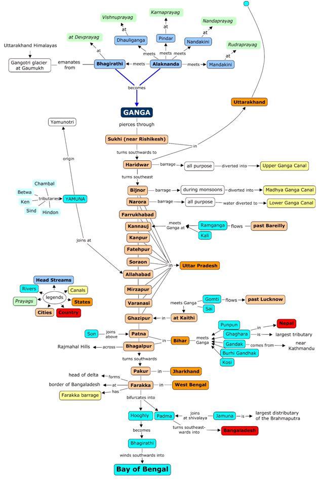
- Alaknanda has source in Satopnath Glacier near Badrinath its 2 tributarie are Dhauli, Vishnu Ganga, Pindar, Madakini/Kali Ganga.
- Ganag passes through 4 states Ukhand, UP, Bihar, WB.
- Yamuna originates in Yamunotri near Bhandarpunch range.
- Hindan, Rind, Sengar, Varuna are left bank tributaries.
- Gandak rises b/w ==Dhaulagiri and Mount Everest==.
- Kaligandak, Trishulganga are 2 of its tributaries.
- Ghaghara originates in Mapchachungo glacier.
- Tila, Seti, Beri and Sarda are its tributaries.
- Kosi rise north of Mount Everest.
- Arun, Tamur Kosi are lesser known tributaries.
- Ramganga rises in Garhwal Hills near Gairsain.
- Sarda or Kali rises in Milam glacier in Nepal aka Goriganga, tributary of Ghaghara.
- Mahananda rise in Darjeeling hills.
- Son originates in the Amarkantak plateau.
Brahmaputra System
Section titled “Brahmaputra System”- originates in Chemayungdung glacier of Kailash range near Mansarovar lake.
- Burhi Dihing, Dhansri are left bank tributaries
- Subhansri, Kameng, Manas and Sankosh are right bank
- known for floods, channel shifting, bank erosion.

Peninsular Drainage
Section titled “Peninsular Drainage”- Evolution :
- Subsidence of western flank -> its submergence below sea
- Upheaval of Himalayas and subsequent subsidence of Northern Peninsular block -> this is where Narmada and Tapi flow.
- Tilting of Peninsular block from the Northwestern to Southeastern direction
- older; forms broad, graded shallow valleys
- Fixed course, absence of meanders, non perennial flow.
- Mahanadi rises near Sihawa in Raipur.
- Godavari aka Dakshin Ganga rises near Nashik, heavy floods in lower reaches where it forms gorge.
- Krishna rises near Mahabaleshwar, Koyna is lesser known tributary.
- Kaveri rises near the Brahmagiri hills of Kodagu.
- Narmada rises in the Amarkantak plateau.
- Tapi originates from Multai in MP.
- Luni originates near Pushkar, ephemeral.
- Juari is a river in Goa; Ponnani aka Bharatphuzha is largtest river of Kerala.
The break in monsoon is caused by :
- Rain bearing clouds are not very frequent along the ITCZ.
- Winds blow parallel to the coast.
Rainfall in India does not occur in the winter due to :
- Winds moving from land to sea do not have moisture.
- Anti-cyclonic circulation on the land.
Local Storms of hot weather :
| Name of Storm | Place |
|---|---|
| Mango Showers | Kerala and Karnataka |
| Blossom Showers | Kerala |
| Kal Baisakhi | Bengal and Assam |
| Bardoli Chheerha | Assam |
Tamil Nadu does not get rainfall during the monsoon seasons is because :
- Parallel to Bay of Bengal branch
- rainshadow area of Arabian sea branch
October heat is cause due to :
- clear skies and rise of temp due to retreating monsoon.
- High humidity
Indian Monsoon
Section titled “Indian Monsoon”- period from June to September is called as Southwest Monsoon period.
- Factors influencing SW Monsoon are :
- Differential heating and cooling of land and water creates low pressure on landmass of India while seas experience high pressure.
- ITCZ is where SE trade and NE trade winds meet its shifting influences rain too.
- Presence of high pressure area east of Madagascar ie 20deg South also affects Monsoon rains.
- Heating of Tibetan plateau causes clockwise circulation in middle troposphere that develops into easterly jet stream. This intense heating positively correlates well with Indian monsoon.
- ENSO : La Nina would cause better mosoon in India and drought in South America and El Nino would cause drought like conditions and dec in rainfall in India.
- [[1.4 Oceans and Coastal Landforms.md|Oceans and Coastal Landforms]]
[[kegy101.pdf]] - India Location [[kegy102.pdf]] - Structure and Physiography [[kegy103.pdf]] - Drainage System [[kegy104.pdf]] - Climate Vegetation and Soil